Frequently Asked Questions
About Civ Robotics
How long has Civ Robotics been around?
Top tier EPCs have been deploying CivDots in the field since 2021 and have been continuously using our products on a variety of construction projects (Solar Farms, Ground Improvements, Earthworks, Roads, Foundations, Construction Staking, the list goes on).
In 2022, Trimble Inc. invested in Civ Robotics and continues to support our growth.
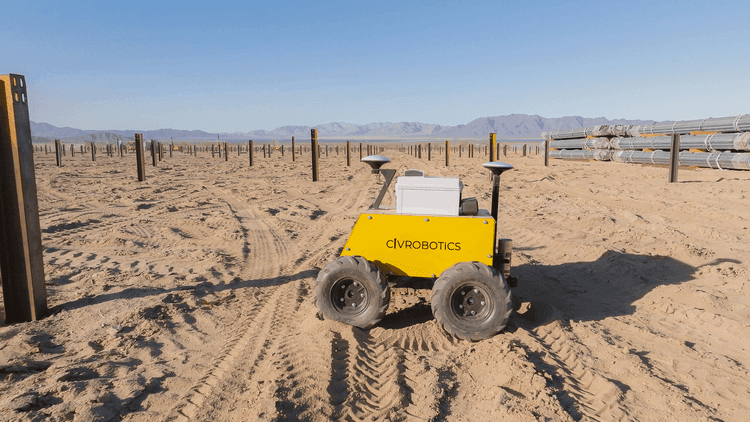
How reliable is the CivDot / CivDot+?
The rugged, versatile and reliable CivDot+ is an ideal tool for construction projects with tight tolerances. The Robot is very rugged, with 10” ground clearance for smooth operation in any field. The most common issues include flat tires and negligence.
Civ has a thorough validation process. Before the rover will mark, it will validate that the CivDot’s position is within the tolerance, and ensure that it only marks at the given accuracy.
How reliable is CivNav?
CivNav is a rugged, machine-mounted system designed for daily use on solar construction sites, including dusty and uneven field conditions. It uses dual RTK technology to guide operators where to place piles and pallets with high accuracy.
Before placement, CivNav displays live GPS quality so the operator can confirm the system is within tolerance.
How does Civ Robotics improve construction productivity?
By automating layout, Civ Robotics helps teams work up to 8x faster than manual methods. With real-time reporting, IMU tilt corrections, and compatibility with top gps land survey equipment, our robots reduce labor costs and minimize rework.
About our products
How does CivDot reach the desired accuracy?
Our system includes Dual RTK for heading as well as an IMU sensor for tilt correction during the navigating, marking and validation process.
Can I connect CivDot to my base station?
CivDot can connect to any base station (Trimble, Leica, Topcon, etc.) and to your choice of NTRIP / VRS network.
What kind of spray paint is CivDot compatible with?
We recommend Rust-Oleum Inverted Marking Paint, however any inverted marking spray paint can be used on the CivDot available at your local hardware store.
What is CivDot used for in construction?
CivDot is a robotic layout machine designed for automated topographic surveying and mapping. It can mark up to 3,000 points per day on jobsites like solar farms, grading projects, and land surveys, using GNSS survey equipment for accuracy down to 1/10’ (30 mm).
How accurate is the CivDot+ layout robot?
CivDot+ offers laser-guided precision with accuracy down to 3/100’ (8 mm). It’s ideal for pile driving, road markings, and projects that demand a GPS layout tool with high-precision layout capabilities.
What types of projects is CivDot Mini best for?
CivDot Mini is built for parking lot striping, roadway layout, and airport runway markings. It delivers sub-inch (2 cm) accuracy using spray paint, automating up to 17 miles of solid or dashed line markings per day.
What types of projects is CivNav best suited for?
CivNav is best suited for solar EPCs looking to simplify material distribution across large construction sites. It guides operators where to place piles and PV modules directly from the blueprint, and can eliminate construction staking when used alongside GPS-enabled pile drivers.
What is the difference between CivDot+ and CivNav?
CivDot+ is a robotic layout system that marks points on the ground, while CivNav guides operators to place materials without performing layout. In solar projects with GPS pile drivers, CivNav can eliminate the need for layout by directing material placement from the design. CivDot+ is still preferred when layout is required, such as on sites without GPS-enabled installation equipment. This also means no physical markers such as whiskers or flags are needed.
Operating the CivDot
How many people in a crew?
Typically, a survey crew consists of an operator and nailer. The CivDot or CivDot+ only needs one person to operate the machine.
What training is required to operate the CivDot? What about on-site training?
The CivDot can be operated by anyone - no special license or skill set is required. A field application engineer will visit your site and train your field team how to operate the machine safely and efficiently. The on-site training takes a day, and then you'll be ready to go!
What kind of files can be used in CivPlan? What data prep is needed to operate the CivDot?
CivPlan supports CSV files for marking points, and DXF files for line work. The template will be provided to the field team during on-site training and meet industry standards (name, northing, easting, elevation, annotation).
Does CivPlan support local coordinate systems?
CivPlan supports local coordinate systems and will require the state plane coordinate name and site calibration file. You could also perform a site calibration process through CivPlan.
What GNSS receivers are compatible with Civ Robotics?
Civ Robotics construction layout robots work with Trimble R780, Topcon, Leica, and NTRIP-based GNSS correction networks. This ensures reliable RTK precision across construction layouts, even in challenging site conditions.
What types of construction projects benefit most from CivDot?
CivDot is built for solar energy construction, topographic surveying and mapping and construction staking. Its rugged design and GNSS integration make it ideal for high-output layout in remote or uneven field conditions.
Operating CivNav
CivNav is used by an operator on a machine. Does this have to be a certain type of machine?
CivNav can be mounted on any machine, rental or one you own. Most common machines for shaking out piles and pallets in solar are skid steers and telehandlers from Bobcat, Takeuchi, Caterpillar and John Deere.
How do I upload the solar blueprint or design file into CivNav?
Solar design files are uploaded into CivNav through the planning interface using industry-standard CSV files. The planning interface is used to define missions, and these missions are then executed on the operator’s device during field operations. CivNav supports different pile colors and length with many features to fit your workflow
How does the operator follow CivNav guidance inside the cab?
The operator follows CivNav guidance on a tablet device. The interface shows the operator’s location and the next goal on a top-down map. The operator uses this guidance to place materials as instructed with pin point accuracy.
Environment
Can CivDot handle any type of terrain?
CivDot can handle any terrain 30° slope thanks to its 10” (25cm) ground clearance and various tire options for mud, sand, roads, etc.
Can CivDot operate in any weather condition?
The CivDot is weather resistant, has IP65 rating, and operates in harsh climates. We like to remind our customers that since we use GPS/ GLONASS/ Galileo/ BeiDou/ IRNSS/ OZSS/ SBAS constellation support, the precision of the GPS tracking antenna may suffer if it is covered in thick ice or snow.
Quality Assurance
What is the battery life?
CivDot Operates for 10 hours with one battery swap. The battery has a 4 hour charging time.
What safety and quality assurance features are included?
CivDots are equipped with obstacle detection and an emergency stop button. The operator has the ability to drive in manual mode at any point in time. CivDots will not move nor mark when RTK fix is lost. Additionally, for vertical accuracy, CivDot can shoot the point for your desired duration of time based on the level of accuracy you’re looking for.

© 2026 Civ Robotics inc. All Rights Reserved.